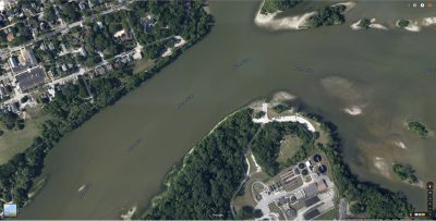
Click on map for full resolution
Orleans Park has a small boat ramp and at low water levels you can wade almost across the entire river. When the water level is below 582, you can walk almost all the way across to Audobon Island and White Street. There is a deep channel that runs between Orleans and the Audobon Islands and you have to wade carefully when you are further out.
Fishing in the Orleans area below 582 feet is not very productive and most anglers will go farther upstream to Bluegrass, Buttonwood, Fort Meigs, and Jerome Road areas.
This area of the river is very wide and shallow and the current is usually much slower than other areas. You will need lighter weights, 1/2 oz or less. If there is significant rain and the water levels and flow are high, then the usual 3/4 oz weights will work just fine. From the Orleans boat ramp to the tip of the Audobon Island straight north, the river is 230 yards across.
On the south side of the river, downstream from Orleans, as you are heading towards Hood Park, there are some nice eddies and areas of much less current where you can
easily fish from shore. Walleye will hold in there at times and strike out at food in the main channel. These areas aren’t very deep either. But they also aren’t very productive. You can wade here to try to reach the deep channel. You can catch walleye here, but not as much as wading out further and fishing the deep channel and holes.
The afternoon is when Orleans usually get going if the water level is high enough. Wade as far as you can and drop your rigs into the middle deep channel. But again, at water levels below 582, you probably need to go further upstream.