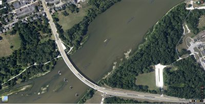
Click on map for full resolution
Below the Maumee Perrysburg Bridge, on the north side, there is a deep channel that is very close to shore and can easily be fished from shore. There aren’t a lot of waders out here and it would be easy to fish from shore.
The area on the north side of the river under the bridge and downstream of it is still called Towpath all the way down till White Street.
You can wade here, but again, you can’t venture too far, because the deep channel is very close to the north side of the river. Most waders wade here, mainly to avoid brush when
reeling in.
The south side is still technically Fort Meigs area, and if you park at Fort Meigs and walk along the shore downstream, you can fish this area. This area merges with Orleans Park
area.
Also on the south side, you see a white oval parking lot for a park. You can park there and take a walk down the trail through the woods to the river. Go west and north and you’ll hit the river. Its the same parking lot that you turn into off Conant Street to eventually get to the Orleans Park area. But instead of going down the winding roads, passing up the water treatment plant, you just stay in that first parking lot. The nice thing about this area, is that you will be there by yourself, very few angler’s go to this area. And there is a nice deep channel to fish.
You will notice there are some nice shallow shelves for anglers to stand on just downstream of the bridge on this south side of the river. The south side isn’t pressured as
much and you may get more bites here, especially as you head closer to Orleans.

